

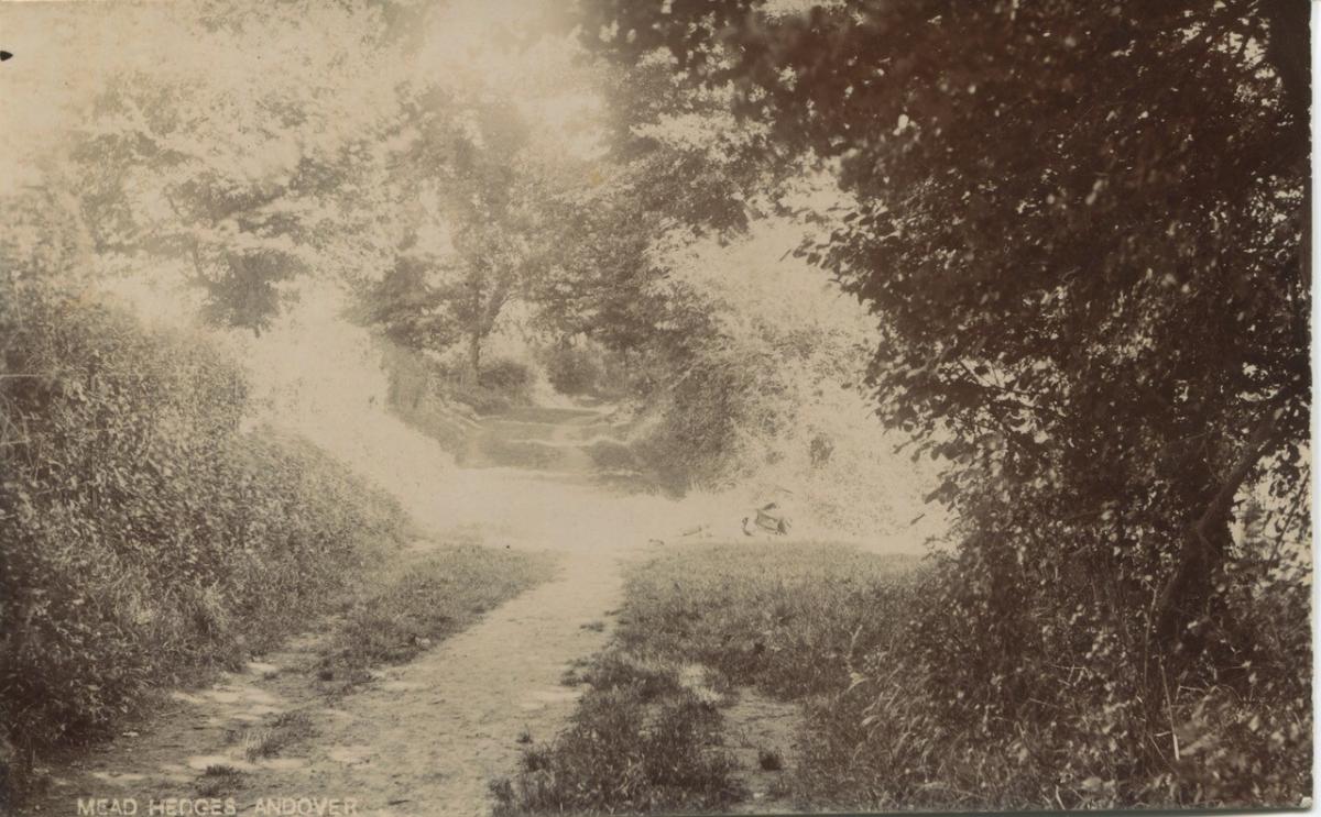
THIS rather faded photograph of Mead Hedges on the western side of Andover was taken by Frederick Pearse 120 years ago. The lane has now of course completely changed, with houses on both sides, but the tight right-hand bend in the far distance suggests only one likely spot.
Two hundred years before this photograph was taken – prior to the building of turnpike roads - Mead Hedges was the main western route out of Andover. The late George Brickell, who was a local historian and worked for The Advertiser, studied this subject and I draw on some of his writings for what follows.
We have to imagine that after crossing the little bridge over the Westbrook, somewhere around the Western Avenue junction in Bridge Street, there was no Western Road leading to the top of the hill where the Millennium Man now stands and no Salisbury or Weyhill roads.
That area of land belonged to the leper hospital or spittle, a local charity that had re-located from a former, more distant, site at Stretchacre - around the area of Floral Way - to much nearer the town, after the threat of leprosy had largely died out in the 17th Century.
When the turnpike road to Salisbury was built in the 1750s, the trustees of the new road had to pay the spittle charity an amount of compensation for the loss of land. A similar thing happened when the Weyhill Road or Amesbury turnpike was constructed some years later, suggesting both were new routes – though there may have been former, ancient tracks.
So instead of going from Bridge Street up the hill to get out of Andover, it was necessary to take a left turn and follow the track along Mead Hedges.
Today, Mead Hedges begins at a point farther west than formerly but the old path seems to have run along the west side of the Station hotel before climbing above the spring known as St Ann’s Well - a marshy area - and then dropping down again to join the present footpath.
From here, this main route to the west meandered down to Rooksbury Mill and then veered north-westwards up the hill, along a former Millway or ‘Mullewy’, and across to the present junction at the top of Weyhill Road, known for years as Hundred Acre Corner. Travellers to Salisbury were then able to follow the old Roman Portway through Monxton and Grateley.
But why the name Mead Hedges? Mr Brickell speculates that it may have been because it followed the mead edges.
The path was on the edge of the mead and was passable for most of the year, whereas any further south would have been subject to flooding.
In medieval times, the bailiff or mayor of the town had the right before others to send his pigs onto the mead or common pig marsh, once it was fit for grazing.
And in more recent years, the same land has been used extensively for the growth of watercress.
Here too, in Mead Hedges, it has been suggested that the Battle of Andover was fought during the Civil War in 1644, though opinions vary as to its likely site or the numbers involved. Whether battle or skirmish, the King’s forces marched from Salisbury and clashed with Sir William Waller’s troops, somewhere near Andover – maybe in Mead Hedges but more likely near Red Post bridge, on the road to Monxton.


Comments: Our rules
We want our comments to be a lively and valuable part of our community - a place where readers can debate and engage with the most important local issues. The ability to comment on our stories is a privilege, not a right, however, and that privilege may be withdrawn if it is abused or misused.
Please report any comments that break our rules.
Read the rules here